A week ago Saturday, my three Honors students and I went on a field trip led by Gary Fleeger of the Pennsylvania Geological Survey, to examine some cool glacial features in western Pennsylvania. The trip was associated with the joint meeting of the northeastern & north-central sections of the Geological Society of America, held in Pittsburgh.
My favorite part of the trip was examining a glacial delta complex near Jacksville, Pennsylvania. We started off with a real treat: checking out the Jacksville Esker:
Here’s a link to a much bigger version of this photograph.
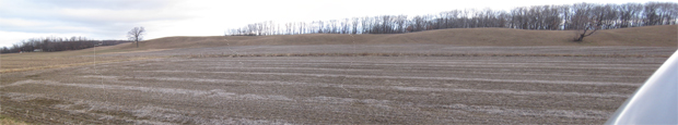
This was my first-ever actual real-life esker. It was pretty cool. Here’s a Google Map “terrain” view:
The first photo was taken from W. Liberty road, a bit east of the intersection with Dickey Road, looking north.
The sediment that comprises this esker was deposited by a stream flowing within glacial ice, and transporting meltwater (and its entrained sediment) out and away from the glacier, in this case towards the southeast. There, the meltwater reached a lake that had formed in front of the glacier (a so-called proglacial lake), where the sediment was deposited in a large delta that grew (“prograded“) out into the lake over time. The lake here has long since drained away, just as the glacier that produced it has melted, but the sediment is still there. This is not the superlatively-poorly-sorted glacial sediment that we call “till,” but a more washed, tumbled, processed, sorted, and overall mature package known as “outwash.” Because it’s concentrated in sand and gravel (and relatively deficient in boulders and mud), outwash deposits make for good places for people to get the sand and gravel we need for construction. The Glacial Sand and Gravel Company is quarrying the delta deposits near Jacksville, and they were kind enough to let us visit their operation to check out the sediments. Here’s some of our crew in the gravel pit:
See those tilted layers? Those are foreset beds from the proglacial delta. They aren’t horizontal beds that were later tectonically tilted — this is more or less the inclination at which they were deposited.
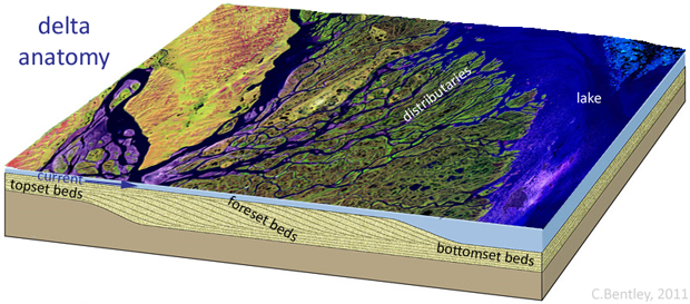
As a river flows into a calm body of water like the ocean or a proglacial lake, the water loses velocity. It can’t carry as much sediment when it’s flowing slowly, so the sediment gets deposited. This forms a delta. Some of the sediment gets deposited at the bottom of the delta’s multiple channels, called distributaries. These distributary deposits are more or less horizontal, and relatively thin in spite of being coarser-grained (because they are in the fastest moving current). They are called topset beds. Sediment dumped off the advancing “nose” of the delta (at the outer tip of the distributaries) is deposited at a slight angle, and these are the foreset beds you see in the picture above. In the deeper, calmer water, we get more horizontal beds, but they are finer-grained due to calmer depositional conditions. These are the bottomset beds.
My favorite part of the trip was examining a glacial delta complex near Jacksville, Pennsylvania. We started off with a real treat: checking out the Jacksville Esker:
Here’s a link to a much bigger version of this photograph.
This was my first-ever actual real-life esker. It was pretty cool. Here’s a Google Map “terrain” view:
The first photo was taken from W. Liberty road, a bit east of the intersection with Dickey Road, looking north.
The sediment that comprises this esker was deposited by a stream flowing within glacial ice, and transporting meltwater (and its entrained sediment) out and away from the glacier, in this case towards the southeast. There, the meltwater reached a lake that had formed in front of the glacier (a so-called proglacial lake), where the sediment was deposited in a large delta that grew (“prograded“) out into the lake over time. The lake here has long since drained away, just as the glacier that produced it has melted, but the sediment is still there. This is not the superlatively-poorly-sorted glacial sediment that we call “till,” but a more washed, tumbled, processed, sorted, and overall mature package known as “outwash.” Because it’s concentrated in sand and gravel (and relatively deficient in boulders and mud), outwash deposits make for good places for people to get the sand and gravel we need for construction. The Glacial Sand and Gravel Company is quarrying the delta deposits near Jacksville, and they were kind enough to let us visit their operation to check out the sediments. Here’s some of our crew in the gravel pit:
See those tilted layers? Those are foreset beds from the proglacial delta. They aren’t horizontal beds that were later tectonically tilted — this is more or less the inclination at which they were deposited.
As a river flows into a calm body of water like the ocean or a proglacial lake, the water loses velocity. It can’t carry as much sediment when it’s flowing slowly, so the sediment gets deposited. This forms a delta. Some of the sediment gets deposited at the bottom of the delta’s multiple channels, called distributaries. These distributary deposits are more or less horizontal, and relatively thin in spite of being coarser-grained (because they are in the fastest moving current). They are called topset beds. Sediment dumped off the advancing “nose” of the delta (at the outer tip of the distributaries) is deposited at a slight angle, and these are the foreset beds you see in the picture above. In the deeper, calmer water, we get more horizontal beds, but they are finer-grained due to calmer depositional conditions. These are the bottomset beds.


0 komentar:
Posting Komentar